Rural areas and Google Transit: some findings and opportunities for improvement (Part 1, Walking)
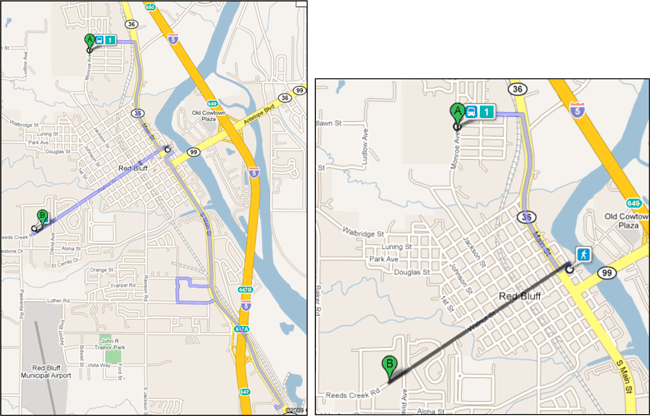
UPDATE (26 August 2010): Google Listens! Note that the two examples of non-optimal walking and transit itineraries included in this blog post have been improved in Google Maps. Now, this itinerary in Red Bluff, California, on Tehama Area Rural Express shows an itinerary with travel by bus all the way to the destination. More in an update post.
Earlier, I posted on the availability of the Northern California Google Transit Feasibility Study which Trillium prepared for Shasta County Regional Planning Agency.
Since Google Transit has most been often implemented in larger metropolitan regions, and has more users in those metropolitan regions, trip planner features are (naturally) often geared more towards metropolitan use cases. One of the purposes of the Shasta County/NorCal Google Study was to catalog issues with the Google Transit trip planner in rural areas and with rural system features — using real data with Plumas, Shasta, Siskiyou, Trinity, and Tehama counties.
You can read the details of issues beginning on page 35 of the Feasibility Study. For those who would prefer not to download the PDF, I thought I would share some some highlights on this blog.
Originally, my plan was to put the entire discussion of issues in one post. When I started that project, I realized there was way too much text for one post, so I’m going to spread out discussion into a series of posts. That will help focus comments and discussion around particular interests and issues.
I don’t want to seem like I’m picking on Google Maps and the transit team. Sometimes people will zero in on problems and flaws with Google Maps and Transit, and I find myself defending the mapping application and approach behind it, which is to launch early and learn through testing with real users and data. Building an application of the scale of Google Maps seems a bit like building an airplane in mid-flight (the analogy isn’t originally mine; I borrowed it from an EDS television advertisement) — there are millions of users, at least 40 languages, and lots of complicated data. It’s hard to build a platform that serves every transit system and user equally well on a global scale.
I hope this feedback helps to improve Google Maps transit directions. Mostly, I hope that by posting on this blog and inviting comments here and around the web, it will at least improve the overall quality of discussion and feedback for Google Maps improvements.
So, without further ado, the theme of the day is walking as part of Google Maps transit directions in rural areas.
ISSUE: Trip planner returns walking directions instead of available transit option for complete trip or segment
Some travel itineraries on loop routes may involve indirect travel paths and correspondingly long on-vehicle passenger travel times. Travel times can be longer in rural systems because transit networks are designed for coverage (serving dispersed needs in the area) rather than productivity (building ridership by serving choice riders and commuters). In cases where the trip planner calculates walking is a faster alternative to transit over all or part of a transit route, the trip planner does display options that minimize travel time, but may add unnecessary walking.
For an example, below: A more ideal display of a trip on TRAX Route 1 (Photoshop mockup, left) and TRAX Route 1 trip as it currently displays (right).

This software decision produces optimal travel itineraries for individuals that do not mind and are able to walk distances of, for example, 0.5 or more miles. However, the result does not serve the needs of mobility-limited customers, customers with heavy bags, or people in rainy, cold, or wet places would want to avoid exposure to nasty weather.
This is a tricky issue because some passengers (like me) usually want the fastest possible itinerary even if it requires extra walking. Others do not. Inclement weather or heavy bags may make additional walking less desirable for a passenger. Some ideas that have been discussed with Google and on the various discussion groups with agencies, consultants, and Google are: (1.) including a checkbox to “minimize walking distance” in the Google Transit trip planner UI, or (2.) including a field to specify maximum walking distance.
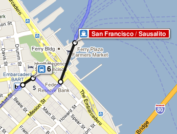
 This issue seems especially tricky. When I use Google Maps, I see some cases where I wish it suggested less walking and others where it suggested more walking. Here’s an example where Google Maps should suggest a little more walking and less transit (screenshot right). It would make more sense to walk directly from the SF Muni F Line to the SF Ferry Building and board the ferry service to Sausalito. But instead, Google Maps suggests a more round-about tour. And in other cases, like above, Google Maps suggests walking a fair bit of walking when transit is available almost to the doorstep of the destination. So I appreciate the challenge of building a system that gives intelligent itineraries when there may be a many factors and considerations at play.
What do you think is the best way to address walking as part of transit directions?
One thought on “Rural areas and Google Transit: some findings and opportunities for improvement (Part 1, Walking)”